Detection of Brittle Shear Zones in Mesoscale Photographs

Journal of Indian Geophysical Union (JIGU) 2022


Poorvi Hebbar, Soumyajit Mukherjee, Narayan Bose
Indian Institute of Technology Bombay, Indian Institute of Technology Kharagpur

Paper Report Experiments Code

Study of structures and fabrics from different scales of observation is an indispensible first step in structural geology. Collecting images of brittle shear zones and discerning the corresponding rock fracture planes with their orientations is a very tedious and expensive process since it’s entirely supervised. For data collection and classification, the geological experts need to carefully observe, capture, label and annotate the mesoscale images. We therefore propose a possible automated approach to better identify geological shear planes. Notwithstanding, a structural geologists’s first identification and categorization of structures in the field or in other scales continues to be indispensible.


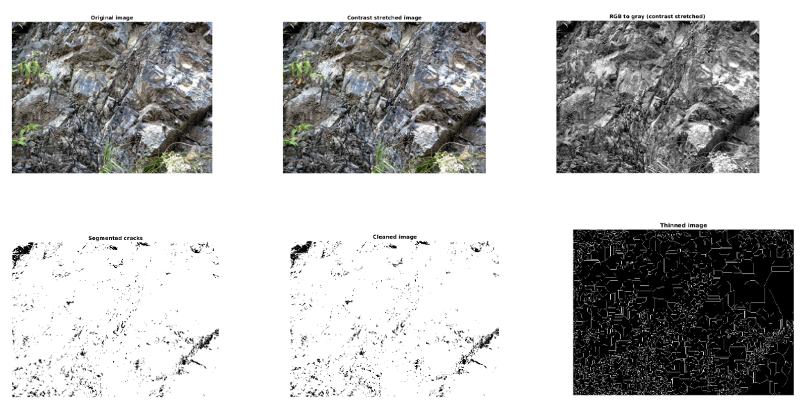
Given a set of images, our objective is to classify them based on their crack types in a completely unsupervised fashion. The training and validation set in fracture datasets consists of a few labelled images while the test set, in contrast, is huge, with lots of unlabelled images to classify. We pre-process every image automatically in terms of its orientation with respect to the ground and also crop them appropriately. Edge-detection and quantization methods are used to accurately detect cracks in enhanced images and we then apply few-shot learning to classify them.


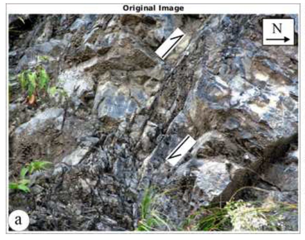
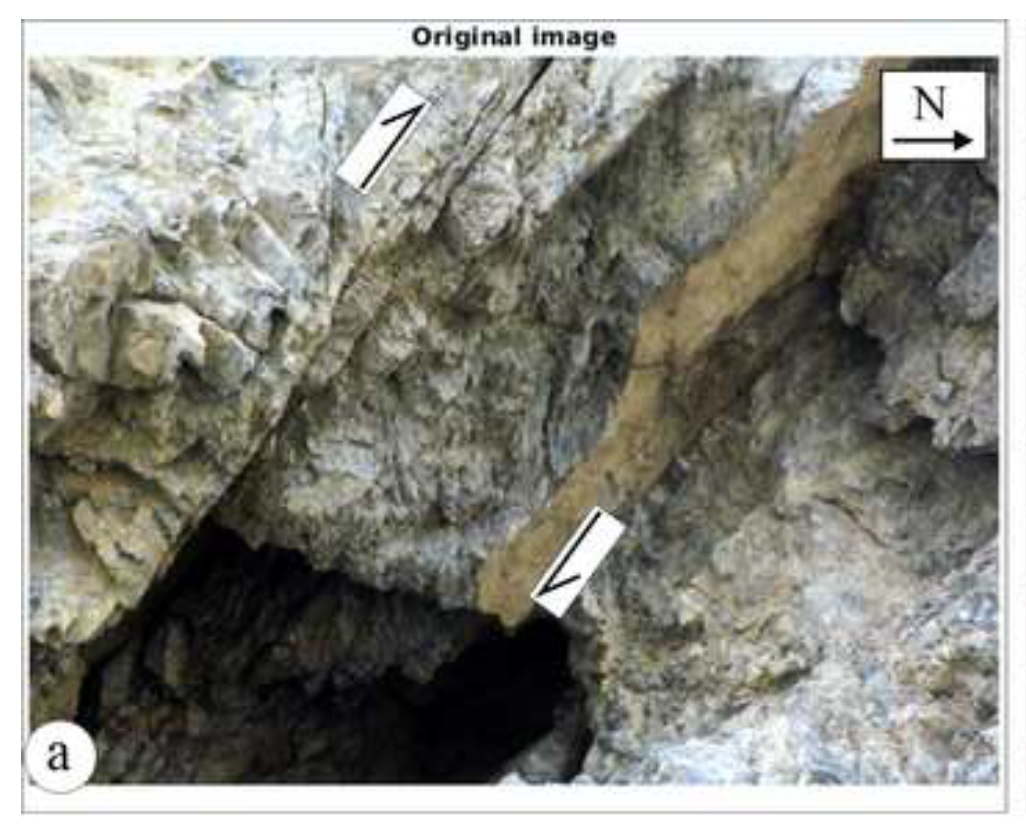
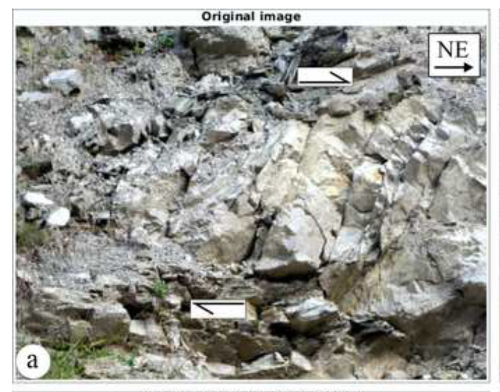
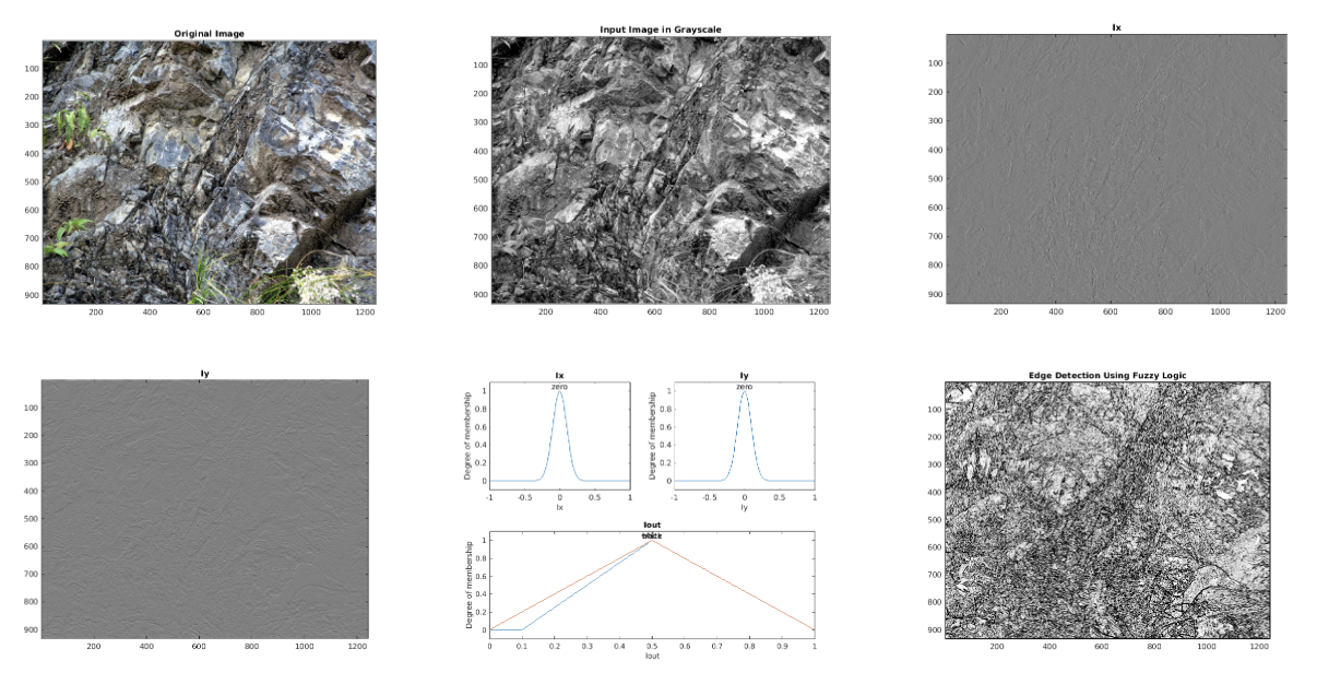
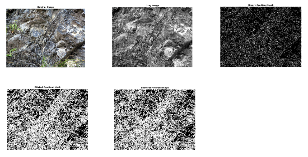
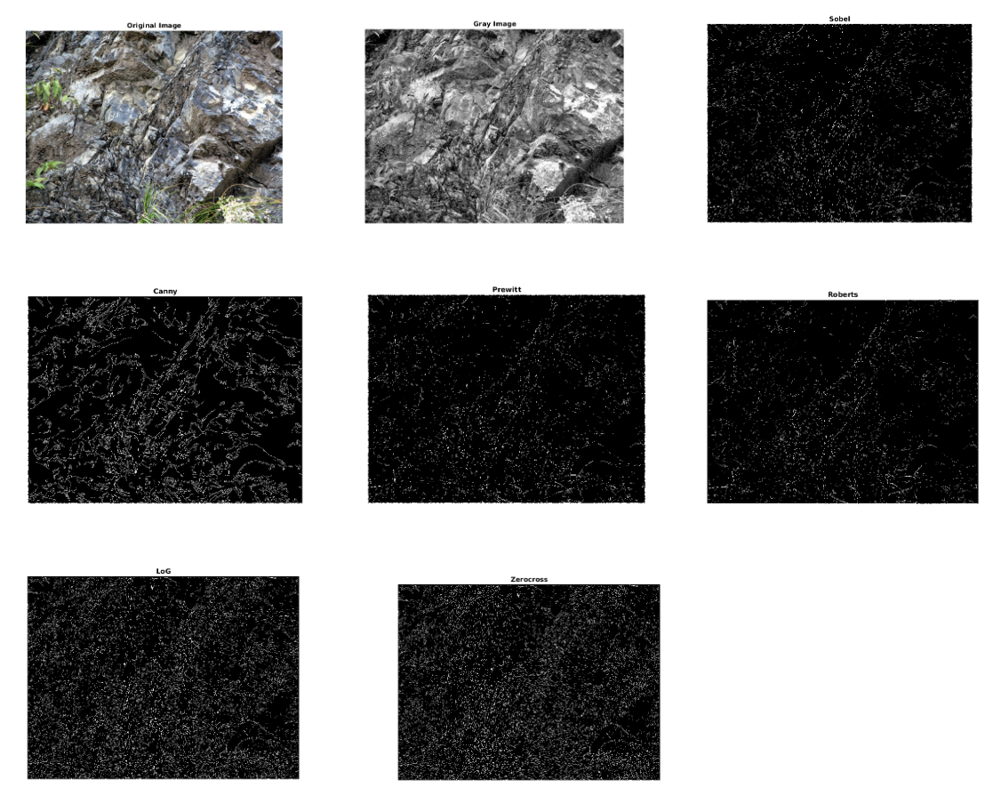
We process three selected images of brittle shear zones using various methods, steps and filters. Such an exercise is more effective to detect brittle planes when the planes are not too close-spaced and is devoid of white fault gouge. Edge detection methods using fuzzy logic seems to be one of the best methods to detect shear planes more distinctly.

Methodology


We explore a total of 4 methods and then determine the one which works the best for most of the validation data for the edge detection task. Once the edges are found, we find the lines corresponding to the tracks by thresholding and then get the approximate orientation of the fracture.

A) Image Segmentation

  • Original Uninterpreted Image
  • Contrast Stretched Image: Improve the contrast in an image by stretching the range of intensity values to span a desired range of values.
  • RGB to Gray image: Convert RGB Images to Gray scale images by taking the average value of the 3 colors at every pixel.
  • Segmented Cracks: Convert the grayscale image to binary image , by replacing all pixels in the input image with luminance greater than a threshold level with the value 1 (white) and replacing all other pixels with the value 0 (black)
  • Cleaned image: Remove isolated pixels (individual 1's that are surrounded by 0's or individual 0’s that are surrounded by 1’s)
  • Thinned image: Thin objects to lines. It removes pixels so that an object without holes shrinks to a minimally connected stroke, and an object with holes shrinks to a connected ring halfway between each hole and the outer boundary.


  • B) Fuzzy Logic Image Processing

  • Original Uninterpreted Image
  • RGB to Gray image: Convert RGB Images to Gray scale images by taking the average value of the 3 colors at every pixel.
  • Ix: Gradient of the intensities of Image pixels in x direction
  • Iy: Gradient of the intensities of Image pixels in y direction
  • Degree of membership vs I: adds a membership function with the specified type and parameters
  • Edge Detections: Use Ix and Iy values to detect edges and mark them as white pixels in the final Image


  • C) Bilateral Filtering

  • Original Uninterpreted Image
  • RGB to Gray image: Convert RGB Images to Gray scale images by taking the average value of the 3 colors at every pixel.
  • Binary Gradient Mask: Convert the grayscale image to binary image , by replacing all pixels in the input image with luminance greater than a threshold level with the value 1 (white) and replacing all other pixels with the value 0 (black)
  • Dilated Gradient Mask: Dilate the binary image, i.e add pixels to the boundaries of objects in an image
  • Bilateral Filtered Image: This is an edge preserving smoothing method where we make a mask with weights for surrounding pixels and convolve it with the original image. The smoothed intensity at every pixel location x1, would be the weighted average of the surrounding pixels. The weight for a pixel location x2, for the intensity to be calculated at x1, is based on:
    i) spatial distance between x1 and x2 (larger the distance, less the weight)
    ii) dissimilarity between the intensity values at x1 and x2 (larger the dissimilarity, less the weight)


  • D) Comparison between commonly used Edge detection algorithms in Image Processing

  • Original Uninterpreted Image
  • RGB to Gray image: Convert RGB Images to Gray scale images by taking the average value of the 3 colors at every pixel.
  • Sobel: uses matrix math to calculate areas of different intensities of an image
  • Canny: uses a multi-stage algorithm to detect a wide range of edges in images
  • Prewitt: uses a derivative mask and can detect only horizontal and vertical edges
  • Roberts: performs a simple, quick to compute, 2-D spatial gradient measurement on an image. It thus highlights regions of high spatial frequency which often correspond to edges. The matrices used are Gx=[[1 0] [0 -1]] and Gy=[[0 1] [-1 0]]
  • LoG: Finds edges by looking for zero-crossings after filtering I with a Laplacian of Gaussian (LoG) filter
  • Zero Cross: Finds edges by looking for zero-crossings after filtering I with a filter that you specify, unlike fixed LoG filter
  • Conclusion and Future Work


    With the support of Prof. Mukherjee, I am happy that I could leverage my interdisciplinary perspective to deduce a unique solution to a challenge faced by geologists today. The orientations of the fractures is quite inaccurate since there are many different ways of interpreting which fracture is the most relavant that needs to be considered. I look forward to applying SIFT or some other feature descriptors and thresholding such that this ambiguity could be diminshed. Proj. Mukherjee and I are also working on similar techniques on remote sensing data.

    Send feedback and questions to Poorvi Hebbar. The website template is borrowed from SIREN.